File:Columbiarivermap.png
外观

本预览的尺寸:600 × 600像素。 其他分辨率:240 × 240像素 | 480 × 480像素 | 768 × 768像素 | 1,024 × 1,024像素 | 1,500 × 1,500像素。
原始文件 (1,500 × 1,500像素,文件大小:3.6 MB,MIME类型:image/png)
文件历史
点击某个日期/时间查看对应时刻的文件。
| 日期/时间 | 缩略图 | 大小 | 用户 | 备注 | |
|---|---|---|---|---|---|
| 当前 | 2022年9月1日 (四) 04:56 |  | 1,500 × 1,500(3.6 MB) | Krib | brightness |
| 2008年10月14日 (二) 16:36 |  | 1,500 × 1,500(3.45 MB) | Kmusser | Increased resolution and numerous small additions | |
| 2008年9月21日 (日) 01:43 |  | 1,000 × 1,000(1.56 MB) | Kmusser | spelling | |
| 2008年4月7日 (一) 19:57 |  | 1,000 × 1,000(1.51 MB) | Kmusser | Added a few more labels. | |
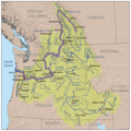
| 2008年4月7日 (一) 17:29 |  | 1,000 × 1,000(1.4 MB) | Kmusser | {{Information |Description=This is a map of the Columbia River watershed with the Columbia River highlighted. |Source=self-made, based on USGS and Digital Chart of the World data. |Dat |
文件用途
以下2个页面使用本文件:
全域文件用途
以下其他wiki使用此文件:
- af.wikipedia.org上的用途
- ar.wikipedia.org上的用途
- ba.wikipedia.org上的用途
- be-tarask.wikipedia.org上的用途
- bg.wikipedia.org上的用途
- bh.wikipedia.org上的用途
- bn.wikipedia.org上的用途
- ca.wikipedia.org上的用途
- ceb.wikipedia.org上的用途
- da.wikipedia.org上的用途
- de.wikipedia.org上的用途
- el.wikipedia.org上的用途
- en.wikipedia.org上的用途
- Columbia River
- David Thompson (explorer)
- List of rivers of the Americas
- Adams–Onís Treaty
- Oregon Country
- Oregon boundary dispute
- Columbia River drainage basin
- List of tributaries of the Columbia River
- User:Kmusser/Images
- Columbia District
- Fort Nez Percés
- Wallula Gap
- Canoe River (British Columbia)
- Ruggs, Oregon
- List of rapids of the Columbia River
- Raft River Mountains
- Wikipedia:WikiProject Rivers/Maps
- List of longest rivers of the United States
- The Dam Cup
- Nutrient cycling in the Columbia River Basin
- User:Nrchristman/sandbox
- User:Falcaorib/Canada, United States and Mexico
- es.wikipedia.org上的用途
查看此文件的更多全域用途。

