跳转到内容

File:Current US military deployments.png

页面内容不支持其他语言。
這個文件來自維基共享資源
维基百科,自由的百科全书

Current_US_military_deployments.png (800 × 353像素,文件大小:42 KB,MIME类型:image/png


此military map图片可使用矢量图形重新创建为SVG文件。这具有很多好处;更多信息请参见共享资源:待清理媒体。如果存在此图片的SVG格式,请将其上传,然后将此模板替换为{{vector version available|新图片名称}}


建议您将SVG命名为“Current US military deployments.svg”,这样在使用Vector version available(或Vva)模板时就不需要填写新图片名称参数。

摘要

描述
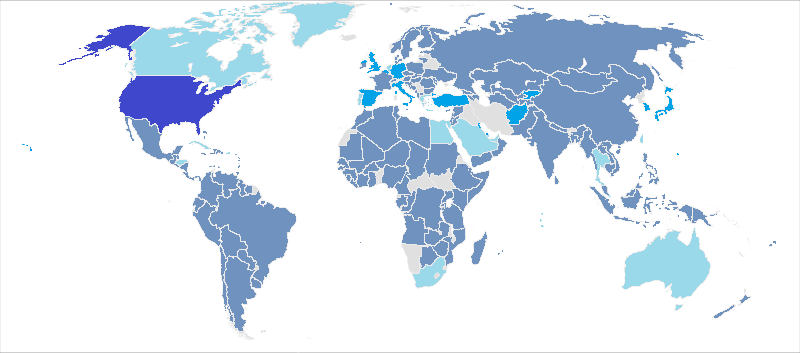
English: This map, using information from the Defense Manpower Data Center is an update of a map previously used for the webpage, United States military deployments by Lokal_Profil with information from 2007. This map has those listed as part of Overseas Contingency Operation Deployments integrated in, while military dependents and civilian personnel are omitted. Legend:
 
No US military men
 
Less than a hundred US military men
 
More than a hundred military men
 
More than 1,000 military men
 
United States

For the map itself, most of those deployments that are less than 100 troops are usually less than fifty military personnel, just for public knowledge.

If you wonder why your country is marked as if there is US military personnel - please check the source (US Defense Manpower Data Center). There is some US military personnel even in such country as Russia (24 persons, as of 2014.10). The deployments are not always in the form of a military base: there are contact groups etc.
中文:2016年底美軍全球部署情形
 
美國本土
 
駐軍超過1,000人
 
駐軍超過100人少於1,000人
 
駐軍少於100人(包括zh:駐外武官
 
无驻军或無數據
日期
来源
作者 Wikiedebs
授权
(二次使用本文件)
我,本作品著作权人,特此采用以下许可协议发表本作品:
w:zh:知识共享
署名 相同方式共享
本文件采用知识共享署名-相同方式共享 2.5 通用许可协议授权。
您可以自由地:
  • 共享 – 复制、发行并传播本作品
  • 修改 – 改编作品
惟须遵守下列条件:
  • 署名 – 您必须对作品进行署名,提供授权条款的链接,并说明是否对原始内容进行了更改。您可以用任何合理的方式来署名,但不得以任何方式表明许可人认可您或您的使用。
  • 相同方式共享 – 如果您再混合、转换或者基于本作品进行创作,您必须以与原先许可协议相同或相兼容的许可协议分发您贡献的作品。

说明

添加一行文字以描述该文件所表现的内容

此文件中描述的项目

描繪內容

ac897ef411650092ea1b019a7e1112b85cec8057

43,303 字节

353 像素

800 像素

文件历史

点击某个日期/时间查看对应时刻的文件。

日期/时间缩⁠略⁠图大小用户备注
当前2016年3月9日 (三) 03:132016年3月9日 (三) 03:13版本的缩略图800 × 353(42 KB)Mahogany115Reverted to version as of 03:11, 9 March 2016 (UTC)
2016年3月9日 (三) 03:122016年3月9日 (三) 03:12版本的缩略图800 × 353(57 KB)Mahogany115marked the location of united states
2016年3月9日 (三) 03:112016年3月9日 (三) 03:11版本的缩略图800 × 353(42 KB)Mahogany115marked united states
2015年4月15日 (三) 13:352015年4月15日 (三) 13:35版本的缩略图800 × 353(63 KB)PrinsgezindeMade a new file instead of updating this one
2015年4月15日 (三) 08:382015年4月15日 (三) 08:38版本的缩略图4,500 × 2,234(208 KB)PrinsgezindeOwn variation based on previous version. Original picture was of a resolution too low to be very helpful. The colors it used to portray the presence were also somewhat confusing, not clearly indicating a pattern in intensity. I took a larger world map...
2014年11月16日 (日) 23:312014年11月16日 (日) 23:31版本的缩略图800 × 353(63 KB)Zhitelewclean up
2013年12月9日 (一) 22:282013年12月9日 (一) 22:28版本的缩略图800 × 353(55 KB)WikiedebsUser created page with UploadWizard

以下页面使用本文件:

全域文件用途

以下其他wiki使用此文件:

元数据