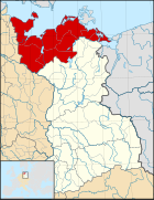
File:March of Lusatia locator map (1004).svg
外觀

此 SVG 檔案的 PNG 預覽的大小:465 × 599 像素。 其他解析度:186 × 240 像素 | 373 × 480 像素 | 596 × 768 像素 | 795 × 1,024 像素 | 1,590 × 2,048 像素 | 1,390 × 1,790 像素。
原始檔案 (SVG 檔案,表面大小:1,390 × 1,790 像素,檔案大小:2.47 MB)
檔案歷史
點選日期/時間以檢視該時間的檔案版本。
| 日期/時間 | 縮圖 | 尺寸 | 用戶 | 備註 | |
|---|---|---|---|---|---|
| 目前 | 2016年12月10日 (六) 17:37 |  | 1,390 × 1,790(2.47 MB) | Alphathon | == {{int:filedesc}} == {{Inkscape}} {{Information |Description={{en|A map of the en:March of Lusatia (German: ''Mark Lausitz'') around 1004 CE. The map is derived from a vectorised version of one found in Professor G. Droysens Allgemeine... |
檔案用途
下列頁面有用到此檔案:
全域檔案使用狀況
以下其他 wiki 使用了這個檔案:
- cs.wikipedia.org 的使用狀況
- en.wikipedia.org 的使用狀況
- es.wikipedia.org 的使用狀況
- et.wikipedia.org 的使用狀況
- fr.wikipedia.org 的使用狀況
- it.wikipedia.org 的使用狀況
- ja.wikipedia.org 的使用狀況
- ru.wikipedia.org 的使用狀況
- uk.wikipedia.org 的使用狀況
- www.wikidata.org 的使用狀況


