
File:Leyte map annotated.jpg

預覽大小:413 × 600 像素。 其他解析度:165 × 240 像素 | 330 × 480 像素 | 1,001 × 1,454 像素。
原始檔案 (1,001 × 1,454 像素,檔案大小:251 KB,MIME 類型:image/jpeg)

|
本圖片是以PNG、GIF或JPEG格式上傳。然而,其中包含的資料或訊息,應該重新建立成可縮放向量圖形(SVG)檔案,以更有效率或更準確的方式儲存。如有可能,請上傳本圖片的SVG格式版本。在上傳之後,請修改維基各姊妹計畫中所有使用舊版圖片的條目(列在圖像連結章節中),替換為新版圖片,並在舊圖片的描述頁中加入{{Vector version available|新圖片名稱.svg}}模板,同時移除本模板。
|


摘要
| 描述 |
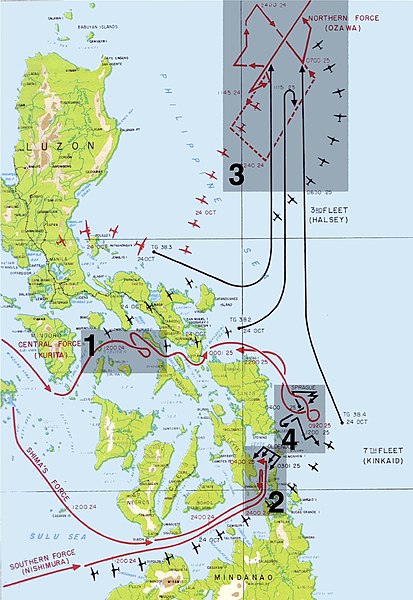
English: The four engagements of the battle of Leyte Gulf:
Español: Mapa de los cuatro encuentros de la Batalla del Golfo de Leyte. |
| 日期 | 2004年10月24日 (原始上傳日期) |
| 來源 | |
| 作者 |
|
| 授權許可 (重用此檔案) |
PD-AUTHOR; Released into the public domain (by the author). |
| 其他版本 | File:Annotated map of Battle of Leyte Gulf.png |
授權條款
| 此作品已由其作者,Gdr at en.wikipedia,釋出至公有領域。此授權條款在全世界均適用。 這可能在某些國家不合法,如果是的話: Gdr at en.wikipedia授予任何人有權利使用此作品於任何用途,除受法律約束外,不受任何限制。
|
原始上傳日誌
The original description page was here. All following user names refer to en.wikipedia.
- 2005-12-15 19:07 Lhgodoy 1001×1454× (199460 bytes) Noise removal in original image
- 2004-10-24 11:00 Gdr 1001×1454× (246741 bytes) Map of the [[battle of Leyte Gulf]], annotated with regions and numbers for the engagements. A public domain modification of [[Image:Leyte Gulf.jpg]].{{PD-USGov-Military}}
This image is a derivative work of the following images:
- File:Map_of_Battle_of_Leyte_Gulf.jpg licensed with PD-USGov-Military-Army
- 2011-01-01T05:16:48Z File Upload Bot (Magnus Manske) 1000x1454 (188596 Bytes) {{BotMoveToCommons|en.wikipedia|year={{subst:CURRENTYEAR}}|month={{subst:CURRENTMONTHNAME}}|day={{subst:CURRENTDAY}}}} {{Information |Description={{en|Battle of Leyte Gulf Source: Scanned from Reports of General MacArthur (
檔案歷史
點選日期/時間以檢視該時間的檔案版本。
| 日期/時間 | 縮圖 | 尺寸 | 使用者 | 備註 | |
|---|---|---|---|---|---|
| 目前 | 2011年7月13日 (三) 18:04 | | 1,001 × 1,454(251 KB) | Hohum | Cleanup |
| 2005年2月18日 (五) 12:17 |  | 1,001 × 1,454(241 KB) | Walter |
檔案用途
下列3個頁面有用到此檔案:
全域檔案使用狀況
以下其他 wiki 使用了這個檔案:
- azb.wikipedia.org 的使用狀況
- bg.wikipedia.org 的使用狀況
- ca.wikipedia.org 的使用狀況
- cs.wikipedia.org 的使用狀況
- da.wikipedia.org 的使用狀況
- de.wikipedia.org 的使用狀況
- en.wikipedia.org 的使用狀況
- es.wikipedia.org 的使用狀況
- eu.wikipedia.org 的使用狀況
- fa.wikipedia.org 的使用狀況
- fi.wikipedia.org 的使用狀況
- fr.wikipedia.org 的使用狀況
- he.wikipedia.org 的使用狀況
- hu.wikipedia.org 的使用狀況
- it.wikipedia.org 的使用狀況
- ko.wikipedia.org 的使用狀況
- nl.wikipedia.org 的使用狀況
- nn.wikipedia.org 的使用狀況
- no.wikipedia.org 的使用狀況
- pl.wikipedia.org 的使用狀況
- pnb.wikipedia.org 的使用狀況
- pt.wikipedia.org 的使用狀況
檢視此檔案的更多全域使用狀況。