
File:SatNordfriesischeInseln.jpg

預覽大小:296 × 600 像素。 其他解析度:118 × 240 像素 | 237 × 480 像素 | 379 × 768 像素 | 1,278 × 2,590 像素。
原始檔案 (1,278 × 2,590 像素,檔案大小:1.63 MB,MIME 類型:image/jpeg)
摘要
| 描述 |
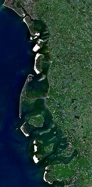
Deutsch: Satellitenaufnahme der Nordfriesischen Inseln (Dänemark/Deutschland) |
| 日期 | 2005年12月21日 (上傳日期) |
| 來源 | Satellite imagery taken from NASA World Wind software (by screenshot) |
| 作者 | NASA |
授權條款
| 本圖像屬於公有領域,因其為NASA的World Wind衛星地圖瀏覽器的一張截圖,且使用了公有領域圖層,如Blue Marble、MODIS、Landsat、SRTM、USGS、GLOBE等。
|
 |
檔案歷史
點選日期/時間以檢視該時間的檔案版本。
| 日期/時間 | 縮圖 | 尺寸 | 使用者 | 備註 | |
|---|---|---|---|---|---|
| 目前 | 2005年12月21日 (三) 18:37 | | 1,278 × 2,590(1.63 MB) | Godewind | * Satellitenaufnahme Nordfriesischen Inseln (Dänemark/Deutschland) * from Nasa World Wind - Free Satellite Image {{PD-USGov}} Category:Satellite photos Category:Satellite images of the islands |
檔案用途
下列頁面有用到此檔案:
全域檔案使用狀況
以下其他 wiki 使用了這個檔案:
- br.wikipedia.org 的使用狀況
- cs.wikipedia.org 的使用狀況
- de.wikipedia.org 的使用狀況
- el.wikipedia.org 的使用狀況
- es.wikipedia.org 的使用狀況
- frr.wikipedia.org 的使用狀況
- hu.wikipedia.org 的使用狀況
- pl.wikipedia.org 的使用狀況
- stq.wikipedia.org 的使用狀況