奧利諾科河
外觀
| 奧利諾科河 Orinoco | |
|---|---|
 委內瑞拉河段 | |
 | |
| 國家 | |
| 流域 | |
| 源頭 | |
| • 位置 | 委內瑞拉帕里馬德爾加多-查爾博山 |
| • 座標 | 02°19′05″N 63°21′42″W / 2.31806°N 63.36167°W |
| • 海拔 | 1,047米(3,435英尺) |
| 河口 | 阿馬庫羅三角洲 |
| • 位置 | 委內瑞拉大西洋 |
| • 海拔 | 0米(0英尺) |
| 流域面積 | 880,000 km2(340,000 sq mi) |
| 本貌 | |
| 長度 | 2,410 km(1,500 mi) |
| 流量 | |
| • 平均流量 | 33,000 m3/s(1,200,000 cu ft/s) |
奧利諾科河(西班牙語:Río Orinoco),是南美洲主要河流之一,全長2,410公里,流域面積88萬平方公里。南美洲第三大河,僅次於亞馬遜河及巴拉那河。
語源學
[編輯]這條河的名字源於哇撈語的「划船之地」一詞,其本身也源於güiri(划船)和noko(那兒)等可通航的地方。[1][2]
地理
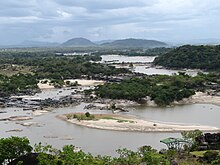
[編輯]奧利諾科河發源於委內瑞拉南部靠近巴西的帕里馬山脈,上游向西北流去,並向南分出卡西基亞雷河注入內格羅河,從而直接溝通亞馬遜河水系。流至瓜哈里博斯急流後進入中游,在聖費爾南多轉而折向北,成為哥倫比亞和委內瑞拉的界河。自梅塔河注入後進入下游,自帕埃斯港起轉而折向東北,最終注入加勒比海帕里亞灣。全河呈半圓形繞過蓋亞那高原。
克里斯多福·哥倫布在1498年8月1日首次發現奧利諾科河河口,但是其源頭最終於1959年方才得到確認。奧利諾科河河口地區是重要的石油和瀝青產區。


參考資料
[編輯]- Stark, James H. 1897. Stark's Guide-Book and History of Trinidad including Tobago, Granada, and St. Vincent; also a trip up the Orinoco and a description of the great Venezuelan Pitch Lake. Boston, James H. Stark, publisher; London, Sampson Low, Marston & Company. (This book has an excellent description of a trip up the Orinoco as far as Ciudad Bolívar and a detailed description of the Venezuelan Pitch Lake situated on the western side of the Gulf of Paria opposite.)
- MacKee, E.D., Nordin, C.F. and D. Perez-Hernandez (1998). "The Waters and Sediments of the Rio Orinoco and its major Tributaries, Venezuela and Colombia." United States Geological Survey water-supply paper, ISSN 0083; 2326/A-B. Washington: United States Government Printing Office.
- Weibezahn, F.H., Haymara, A. and M.W. Lewis (1990). The Orinoco River as an ecosystem. Caracas: Universidad Simon Bolivar.
- Rawlins, C.B. (1999). The Orinoco River. New York: Franklin Watts.
